|
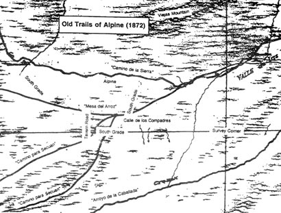
Map of the Old Roads. From the Alpine Historical Society Collection.
by Albert Simonson
The present state highway from Julian through Cuyamaca, Viejas and Alpine pretty much follows George Washington Webb’s San Diego Julian Toll Road, begun in the winter of 1871/72.
George had a kind of “go-for-it” look, as can be seen from photos which hang in Julian’s bank and the El Cajon courthouse lobby. He and his family were among the first settlers in Volcan Valley, now the location of the Julian water well field.
An even earlier pioneer was John Wesley Harrell a bit further down Santa Ysabel Creek. Harrell had attracted the Julian brothers and Georgia relatives like George Webb with tales of feral hogs in a land of plenty. As a purveyor of pork, Harrell became Julian’s first merchant.
Webb’s first road was the “Julian and San Felipe Toll Road” down Banner Canyon to the mines at the foot of the canyon.
It was not a great success. Tolls averaged only three dollars a day. On behalf of Leroy Wilcox, president of the firm, Webb petitioned county supervisors for reduced tolls for lumber teamsters, to kick-start the “Banner City” economy.
Not only that, but Webb had to sue Leroy and Lorin Wilcox to recoup road construction costs that he and Harrell had incurred in the amount of $1078 and change.
Responding to a gold strike at the Stonewall Mine, and confident of Julian’s future, Webb applied for a county charter to build a new toll road already in September of 1871. This time he did not have any partners, just his adult son Samuel.
The following spring, while the summons for the Wilcoxes was being prepared in San Diego, Webb strolled over to the newspaper office for some free publicity.
The March 16 San Diego Union reported, “We were favored yesterday with a call from Mr. G. W. Webb, who is now engaged in building a road from the Valle de las Viejas to Guatay (later renamed Descanso) and thence to the mines of Julian and San Felipe. This is part of the new road for which Mr. Webb has a charter as a toll road.”
The editor mentioned that a work gang of 18 men had spent the winter working on the “horrible Valle de las Viejas hill,” but added, “From thence on to Julian the work is comparatively easy.”
The editor urged the county supervisors to support Webb by adopting Webb’s route “as a county road.”
On September 5 of that year, the county surveyor completed his field notes and map of the San Diego Julian Toll Road. On October 11, county supervisors declared it public road number 10. Webb got paid for his road three years later. Money for roads was scarce, which is why many roads began as toll roads.
Modern route 79 from Julian to the Sunrise Highway turnoff pretty much follows the surveyed road. At that point, the old road went through Cuyamaca meadow with a bearing of south 4 degrees 30 minutes east a distance of 171 chains. One chain equals 66 feet.
That brings us to a point 26 chains due east of what is left of the Stonewall Mine in Cuyamaca State Park. Maybe you can find a trace of the road there, but I saw only a nearby horse riding trail and a suitably inviting saddle between hills to the south.
The toll road continued south through the saddle, with the two Stonewall Peaks on the right hand side, then followed Stonewall Creek for awhile, then Cold Stream Trail and its Indian milling sites to a corner of the erstwhile fence around Mulkins’ place. This is now a popular park trail.
Mulkins had inherited the place from his father-in-law James Lassitor, who had harvested hay in the big meadows, and then skidded the hay down the mountainside to the Vallecito Stage Station of the famous Jackass Mail and Butterfield Stages. After an arduous desert crossing, the horses and mules must have loved that.
The stones of the recently burned Indian museum and park headquarters are said to have come from Lassitor’s stone house. Lassitor was murdered in Arizona while carrying $3,000 in gold dust.
The present road past Green Valley Falls down to Oakzanita Springs follows the old road to “Harper’s.” The names of homesteaders often appear on old surveys. Where there was a good spring, there was usually a homesteader.
There may be many traces of the old road visible in the ruination of Cuyamaca’s firestorm. But the best-preserved section is found on the north slope of Viejas Valley, just upslope from well-traveled Viejas Grade. This section of embankment is visible even from Interstate 8 across the valley.
I once visited that section with two descendants of George Webb’s oldest son Samuel. Sam the third and Sam the fourth have a special fondness for the place.
It seems that young Mary Jane Miller from Campo happened to slip and fall while passing through the 1872 construction site. Samuel rushed to rescue the damsel in distress and of course seeds of young love sprouted in that “horrible Valle de las Viejas hill,” on the way down to the Webb family’s new “Alpine Ranch.” They owe their very existence to her happenstance fall and his gallantry, and that hill.
This story goes on and on, becoming a history of Alpine, of Arizona mining and publishing, of the Gila Canal, and the Border Patrol.
But any story, like life, has to stop somewhere. It will be enough if this story somehow enhances your enjoyment of the beautiful ride through Cuyamaca, a ride which is still, even after the tragic fire, impressive.
|