|
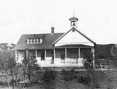
Alpine's Town Hall, built in 1899.
From the Beatrice LaForce Collection.
Photographs
The following three articles were written by local historians to document the early history of the area and the settlement.
by Yolaine Stout
Alpine's long history is a result of its several important topographical, biological and climatic advantages. Alpine lies on a relatively flat plateau, or mesa, in the Cuyamaca Mountains. The mesa was conducive to abundant springs and the mild climate encouraged a diverse plant and animal food source, making the Alpine area particularly attractive for settlement. Calling the mesa "Mata-qu-qual" (mother of life) and the springs "Ha-quan-yon" (no dry; water all the time), the Yuman-speaking Kumeyaay of Hokan stock made the Alpine area their home over 12,000 years ago. The abundant native grasslands on the clay soils of the mesa provided a diversity of food types--such as the tiny seeds of the native grasses, onion bulbs, potato-like bulbs and celeries. Grassland-nesting birds provided eggs and foraging deer and rabbits provided meat. The rich biodiversity in the Alpine area provided an abundance of other useful plants for medicinal and practical purposes. In addition to hunting and gathering, the Kumeyaay also enhanced their food supply by practicing horticulture and animal husbandry. They had a complete system of land and water management to maintain their resources. Archaeological evidence of the Kumeyaay can be found throughout Alpine. Metates along the streambeds, rock alignments and stone chips that remind us of Alpine's important cultural history. Villages and base camps were located throughout Alpine--E-quílsh-a máhk (behind the mountain) at El Capitan Grande and Heish-ow-Na-wa (rabbit house) on Viejas Reservation are examples. Viejas Mountain had sacred importance to all of the Kumeyaay. Called Kwut' ah Lu' e-ah (song dance), the top of Viejas was the site of an annual celebration by the villagers, where they performed ceremonies heralding the arrival of In'ya--the sun. The area of today's reservation was called Ma-ta-terwa (wide open place).
Alpine also lies on the shortest route between the desert to the east and San Diego. Desert tribes, such as the Quechan or Yuman tribes, traveled through Alpine to get to the ocean to gather shells, fish and other ocean products, while trading pottery made from clay from the Colorado River, agricultural harvest and native desert herbs with tribes along the way. Tribes along the coast traveled to the desert for similar reasons. Being on a major trail route, local villagers had the advantage of sharing the latest news and skills. Archaeological evidence also suggests that different tribes camped in Alpine while on their travels.
The first documented Europeans to enter the Alpine area were Pedro Fages, a Spanish lieutenanct colonel, and a small group of soldiers who were stationed in San Diego. They were returning from Yuma in 1782 when they decided to seek out a shorter route than the one they had taken and follow the "old Indian trail" which led from the Cuyamaca highlands down into Viejas Valley. Fages, who later that year became governor of Alto California, returned to the Mission in San Diego with glowing descriptions of nearby lush green grasslands and timber. Frequent visits to Alpine by the Spanish soldiers and missionaries were made in pursuit of pasture and Indian deserters. In responses to these pursuits, the men fled the village of Heish-ow-Na-wa. Finding only women there, the Spanish dubbed the area of the present reservation, "Valle de las Viejas" (valley of the old women). Spanish cattle were soon roaming the mesa grasslands of the Alpine area, destroying a great deal of the Kumeyaay food supply.
A road soon followed through Alpine up to the Cuyamacas used in search of timber for the growing pueblo of San Diego. It extended into Yuma, establishing an important link between the presidios and missions of Yuma and San Diego. The Kumeyaay were eventually coerced into adopting the agricultural practices of the Spanish missionaries in order to survive. All over San Diego, villages were converted to "rancherias." Villagers were compelled and even forced to adopt the Spanish political, religious and social lifestyle. Some villagers kept their Indian names, but most received Spanish names upon being christianized. The leaders of the villages became "mayordomos," and were also given Spanish names. The rancherias of Alpine were particularly attractive to the missionaries for several reasons. At an elevation of 2000 feet, the climate is mild enough for Mediterranean crops and the increased mountain rainfalls extended the growing season. Alpine also had the closest pastureland to the San Diego mission at that elevation. Evidence of Mission-period olive groves, vineyards, fruit orchards and gain fields can still be found in Alpine. A rock wall enclosing a 10-acre agricultural site, foundations, cisterns and dam on Wright's Field are believed by archaeologists to date to the missionary period.
Mission influence peaked in the 1830's, but ranching by the Kumeyaay continued in Alpine until about 1850 when California became a state and any legitimacy of land ownership by Indians was ignored. In 1848, the Spanish-occupied territory of California joined Mexico in declaring its independence from Spain. Just prior to the Mexican Cessation, Pio Pico, the Governor of Alto California, granted vast tracts of land all over California to members of his family and friends. These tracts--called ranchos--were essentially land-grab of the best of the Indian rancherias. Included were the Indian rancherias in Alpine. Over 13,000 acres, or the entire area of Alpine, was given over to Ramon and Leandro Osuna in 1846. The Rancho was called "Rancho Valle de las Viejas y Mesa del Arroz" (tableland of rice--presumably the rice-like grain of the grasslands). The Osuna brothers, however, were unable to establish their claim and 8,877 acres were sold to the wealthy Don Jose Antonio Aguirre, whose family owned the property until at least 1862.
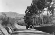
In 1854, Samuel Warnock and Joseph Swycaffer ran a semi-weekly horseback mail route through Viejas from San Diego to Yuma, which followed roughly the same route used by Fages and the Indians before him. It is credited with being the first regular U.S. Mail route in Southern California. It was turned over to James Birch in 1857. He established the San Antonio and San Diego Mail Line. The stagecoach, carrying both passengers and mail, stopped at the Valle de las Viejas, then claimed and operated by the rough English sailor Bill Williams. The mail route, although the shortest route from San Antonio to San Diego, did not operate for long. They utilized mules that were better able to withstand the desert environment than horses. The competitor, James Butterfield, derided Birch's route as the "Jackass Mail Trail" and the U.S. government eventually awarded the mail contract to Butterfield, even though Butterfield traveled first to Los Angeles from San Antonio rather than coming first to San Diego. The "Jackass Mail Trail" ceased operations in 1860, but undoubtedly many passengers had now discovered the Viejas area and came back to stay.
Bibliography
by Albert Simonson and Carol Morrison
After Sherman’s Civil War marched through Georgia, George and Nellie Webb left their plantation for a new life in California’s gold country.
While completing the grading for the Julian-Banner Toll Road in 1871, George learned of a practical route from the mines to San Diego. With seventeen men, he graded the San Diego-Julian Toll Road, effectively determining the site of future Alpine. Since the time of presidio explorers, segments had been called “Camino de Secuan,” “Camino de la Sierra,” “road to Williams rancho” and the “Jackass Mail Trail.” In the 1850’s, this area had been the vast grain and cattle rancho of “Cockney” Bill Williams and “The Saint” Aguirre.
At the location of Shadow Hills Elementary School in Harbison Canyon, then called Oak Grove, George Webb established his “Alpine Ranch,” and built the “Alpine District” first schoolhouse for their six children on the ranch. The new “Alpine” name became notorious with the killing of a Frenchman by George’s son at a midnight rendezvous with the fashionable new schoolmarm, Emma Everhart, in 1875. The son was exonerated.
The Webbs moved on to Sweetwater Valley, then to Arizona to build the Gila Canal. Portions of their toll road remain, to recall for us this dynasty of ambitious, trigger-quick men and their beautiful, resourceful women. Descendants still live in the San Diego area.
What is now downtown Alpine was settled in 1872 by the industrious Nick Overmeir, who took over maintenance of the road with his eight-mule team. It was on his ranch that the first Alpine store, post office and stage station were built (behind the present post office). Nick baled hay and planted fruit trees and vineyards.
With the establishment of the post office, this place, known in mission and ranchero days as Mesa del Arroz and Valle de las Viejas, became officially “Alpine.” The airy new name, coinciding with a tuberculosis epidemic, drew patients from near and far. “Best Climate in the U.S.A. by Government Report.” Picking a marketable name like “Alpine” was a great idea!
Researched by Albert Simonson
1870-1871
Texan Joseph Harden builds house and corral and cultivates four to five acres on land assessed to estate of Jose Antonio Aguirre; Maria del Rosario Estudillo de Ferrer, executrix. Nearest neighbors: Adam Beaty, born 1819, a Confederacy veteran, also Royal Barton who settles Viejas Reservation April 18, 1870 on 160-acre pre-emption claim of September 10, 1867 by Cayetano Cota, probably Indian. Barton was murderer of John Tanahill (October 1877). Harden came here to be near his friend Beaty. Establishes nucleus of present village.
October 15, 1871
Claim of Texas Pacific Railroad to land (effective date of inception). Bars title through February 28, 1885.
1872
Nelson (Nick) Overmier (native born) and Lucy J. Overmier (no children) build house behind present post office (420' south of Arnold Way, 150' east of Olivewood). Nick born 1830. Builds barns and corrals. New neighbor James Green, on Midway Drive. Mr. Webb (near MacQueen school) builds new, shorter road on Midway Drive/Alpine Boulevard alignment, called Julian Road or Viejas Road, to service Stonewall Mine. Old Aguirre ox-cart road and Jackass Mail road bypassed. Land is still assessed to Aguirre estate.
1873
Nick plants fruit trees, sets pattern for later agriculture.
1874 - 1876
New neighbor Edward Foss, on Foss Road. Nick is section roadmaster, at least through 1882.
1871 - 1875
New neighbor Pedro Perez, Mexican, Palo Verde Ranch by small lake. Neighbor "Dutch" Fred Schappelle before 1878 at Lazy A.
1882
Nick bales 60 tons of hay. New neighbor Hugh Field (South Grade).
1883
Nick has vineyards--new industry for area. Neighbor Henry Steil.
1884
Nick has eight-mule team, sets out twenty acres Zinfandel. Has fight with Indians. Vineyards west of post office.
1885
Nick has sixty acres fruit trees. New neighbor Dr. Elijah Love. First official post office. Overmier homestead #716 approved. Area no longer called Viejas. H. J. Whitney and Willis Hurd have general store and feed barns for Stonewall teams. Joe Foster has stage line. New industry--tuberculosis sanitarium with a dozen tents.
1885 - 1888
Nick sells out to Dr. Nugent. Valued at $3,000.
ca. 1888
Dr. Nugent sells to Irish Lord Brabazon. Whitney/Hurd sell business to Charlie Emery. Alpine has 70 children and two stores. Dr. Love's Road (now Marshall).
August 18, 1888
Overmiers' homestead forty acres in El Cajon. Nick thrown from wagon, dies August 25, 1891.
1887
Alpine residents Hurd, Chump, Steil, Mays, Beaty, Field, Finley, J. Love, E. Love, Nugent, Foss, Anderson, Perez, Schmidt, Emery, others in outlying areas.
Sources:
Mexican Land Grants, Bancroft Collection
San Diego Union Archives
Record Group 49 (BLM), National Archives
County Map, 1872
County Survey, 1876
Elliott, History of S. D. and S. B. Counties, 1883
and others
Research Guide to Local History
|